As we think about storm season in Kansas, tornadoes are clearly the most dramatic example. Though they are not the only threat from severe weather, tornadoes can represent the most extreme type of hazard. Therefore, it pays to think through our collective preparedness before tornadoes threaten.
Know your forecast
It is incredibly important, particularly during severe weather season, to keep track of the forecast. While most of us have instant access to weather information at the tip of our fingers, through our smart phone, it pays to keep track of forecasts from official sources. A couple of places to find great information include:
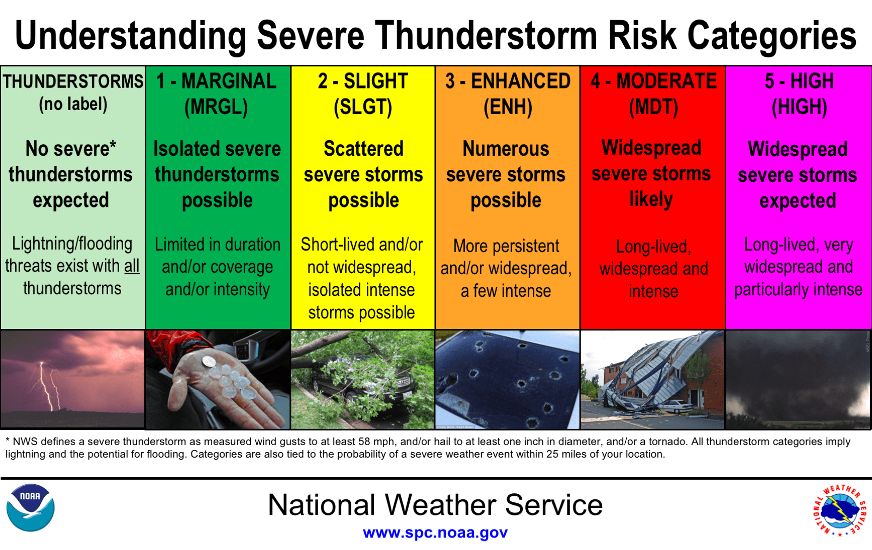
- The Storm Prediction Center provides daily outlooks highlighting potential severe weather chances nationwide. These outlooks categorize severe thunderstorm chances into five different categories as seen in the graphic below. The SPC also coordinates and issues all watches across the nation.
- National Weather Service Forecast Offices. The National Weather Service has local forecast offices all across the United States. Kansas is served by a number of forecast offices, with Manhattan falling under the purview of the Topeka forecast office, Salina under the Wichita forecast office, and Olathe under the Kansas City forecast office. These offices provide regular forecasts for all locations in their county warning areas and, most importantly, are the offices that issue warning.
Know your terms
Even if you have lived in Kansas all of your life, it is important to review the terminology used during a severe weather event.
- A Tornado Watch means that conditions are favorable for the development of severe thunderstorms, including the possibility of tornadoes. Tornado Watches are typically issued over a large area and can be issued several hours before thunderstorms even form. A Tornado Watch should prompt you to pay very close attention to the weather during a particular time period.
- A Tornado Warning means that a tornado has either been spotted or the development of a tornado appears imminent either through reports from storm spotters or based on evidence from Doppler radar. A Tornado Warning is typically issued for a specific storm and therefore covers a relatively small area and shorter time frame. Tornado Warnings provide short-term notice to individuals in the direct path of a storm. A Tornado Warning should prompt you to take immediate action to seek shelter.

Know your plan
While it can sometimes seem like tornado warnings come and go without anything bad happening, it only takes one storm to drastically alter a community and put lives at risk. Having a plan before a storm appear, or a tornado warning is issued, is essential to protect your life.
- Warning reception: How will you receive tornado warning information? Because of our current technology, it is easier than ever to receive tornado warning information directly. This can come in the form of a call, text, or email via K-State Alerts, through the wireless emergency alert system activated on most smart phones, via NOAA weather radio, and through traditional media like TV or radio. Outdoor warning sirens — sometime called storm sirens — also play an important role for individuals who may be outside when a storm approaches. Never rely solely on storm sirens to be your primary or only source of warning information, as they may be hard to hear indoors or at night, and they do not provide any additional context to the threat.
- Shelter location: Where will you go when a warning is issued? The general rule of thumb for tornado sheltering is to get to the lowest level possible and to put as many walls between you and the outside as you can. If your building has a basement, that will be the safest location. If there is no basement, finding an interior room with no windows typically provides the safest location.
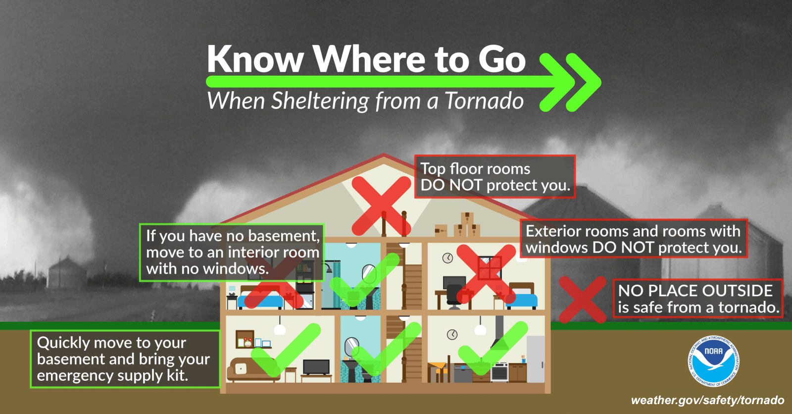
- Shelter supplies: What additional supplies can make a difference when sheltering from a tornado? A few simple items can make a big difference in keeping you safe when sheltering from a tornado. Ideally, you want to try to protect your head, eyes, body and feet. This means putting on a bike helmet or hard hat, safety goggles or lab glasses, a heavy winter coat, and sturdy, closed toed shoes, can all decrease your risk of injury from flying debris. Keeping these items in a go-bag, or in a kit at your shelter location, is a good idea so that you don’t have to try to find things as a storm approaches.
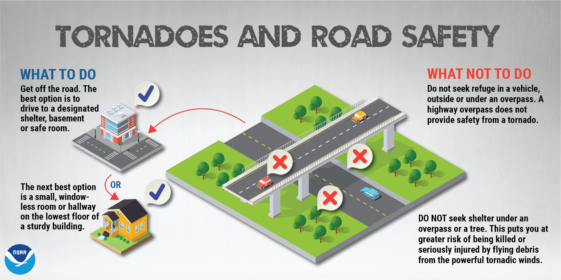
- In a vehicle: To put it simply, being in a vehicle is one of the most dangerous places to be in a tornado. If a tornado warning is issued while you are driving, the safest thing to do is to drive to the closest sturdy shelter. If that is not an option, either park safely on the side of the road, get down in your car, and cover your head, or abandon your car and seek shelter in a low lying area such as a ditch or ravine. Never park or seek shelter under a highway overpass. Please note that THESE ARE ALL BAD OPTIONS. If possible, by following along with the forecast, try to avoid being on the road at all if tornadoes are possible.
- After the storm: Be aware that other hazards may exist after a storm passes. Power lines may be down, debris and broken glass may exist, flooding of roadways may occur, or other storms may be coming. While there may be a temptation to drive around to view damage, if you are safe, and in a safe location, it is typically best to stay put to allow first responders to be able to access areas needing assistance.