Arusha, Tanzania – August, 15-19
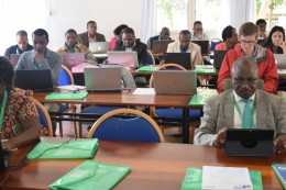
The Geospatial and Farming Systems Research Consortium (GSFRC) kicked off its workshop series in Arusha, Tanzania with 46 early-career research and development professionals from across East Africa gathering to advance their skills in programming, modeling and mapping of spatial data. The workshop was organized by the Feed the Future Sustainable Intensification Innovation Lab, the African Soil Information Service and the International Center for Tropical Agriculture.
Over 300 people applied to attend the workshop and 46 of East Africa’s up-and-coming researchers were selected to attend; each showing both motivation and applicability of this training to their work. The training was free of charge and lodging and meals were provided. Participants traveled from Rwanda, Ethiopia, Kenya, Uganda, Mozambique, and Tanzania and had backgrounds ranging from agronomy, plant breeding and soil scientists to hydrology, climatology, wildlife conservation and virology.
This five-day, hands-on workshop on data science for agricultural development covered an introduction to R software and how to use R for data analysis and modeling with an emphasis on spatial data.
“R is a widely used programming language and software environment that has advanced capabilities for dealing with spatial and spatio-temporal data and provides unparalleled opportunity for analyzing such data,” Dr. Robert Hijmans, director of the GSFRC, said.
Participants learned how to integrate various data types and analytical approaches (e.g. machine learning and simulation modeling) into a single work flow and did so through case studies using climate, soils, crop, human health and remote sensing data.
The coursework was rigorous but motivation throughout the week was high as numerous participants shared just how important this skill set was to the advancement of their specific work. The coursework built upon an online training tool developed by Dr. Hijmans and his GSFRC team which provided a platform of examples and resources for the continuation of learning beyond the workshop and for those who were not able to attend.
Each day, there was an introductory lecture to a new topic followed by hands-on training. The linkage of the hands-on training with the online modules made it possible for participants to reference all tools once the course was over. These online modules also provided further guidance beyond what was feasible to work through during the course of a day by providing introductory discussions on each method, step-by-step trainings, example data sets for further practice, links to useful references and troubleshooting resources. This online resource is a tremendous tool to have as each of the participants return home and begin to apply what they learned to their specific research questions.
The GSFRC online platform has also compiled geospatial data sets as well as country profiles showing examples of what spatial data is available for each country and paired this with training on how to import and use such available spatial data sets for every participant’s own research.
The successful launch of this workshop leads into three more upcoming regional workshops across Sub-Saharan Africa and Southeast Asia.


