Kansas State University

search

Feed the Future Innovation Lab for Collaborative Research on Sustainable Intensification

Tag: geospatial

East African Researchers Attend Spatial Data Workshop Series in Tanzania

Arusha, Tanzania – August, 15-19GSP 074
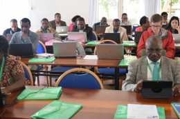
The Geospatial and Farming Systems Research Consortium (GSFRC) kicked off its workshop series in Arusha, Tanzania with 46 early-career research and development professionals from across East Africa gathering to advance their skills in programming, modeling and mapping of spatial data. The workshop was organized by the Feed the Future Sustainable Intensification Innovation Lab, the African Soil Information Service and the International Center for Tropical Agriculture.

Over 300 people applied to attend the workshop and 46 of East Africa’s up-and-coming researchers were selected to attend; each showing both motivation and applicability of this training to their work. The training was free of charge and lodging and meals were provided. Participants traveled from Rwanda, Ethiopia, Kenya, Uganda, Mozambique, and Tanzania and had backgrounds ranging from agronomy, plant breeding and soil scientists to hydrology, climatology, wildlife conservation and virology.

This five-day, hands-on workshop on data science for agricultural development covered an introduction to R software and how to use R for data analysis and modeling with an emphasis on spatial data. Continue reading “East African Researchers Attend Spatial Data Workshop Series in Tanzania”


SIIL Geospatial and Farming Systems Research Consortium to host workshop in Tanzania

The Geospatial and Farming Systems Research Consortium, funded by the Feed the Future Sustainable Intensification Innovation Lab and in partnership with the International Center for Tropical Agriculture, will host a 5 day hands-on workshop on data science for agricultural development on August 15-19, 2016 in Arusha, Tanzania. All Innovation Lab partners working in Tanzania and the surrounding region are invited to attend.

The workshop will include an introduction to the R software, and using R for data analysis and modeling, with an emphasis on spatial data. Case studies will include the use of climate, soils, crop, and health and remote sensing data. Participants will learn how to integrate various data types and analytical approaches (e.g. machine learning and simulation modeling) into a single work flow. The number of participants is limited, and prospective attendees must complete the event application.

There is no cost for attending the workshop. Lodging and meals will be provided, and travel grants may be available upon request. For more information, please contact Ani Ghosh.